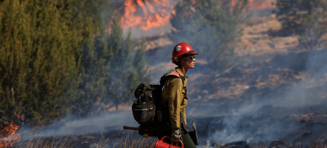
A firefighter conducts a prescribed burn to combat the Hermits Peak and Calf Canyon wildfires in May 2022.
Kevin Mohatt/Reuters/Redux
I
T STARTED WITH smoke settling so thick over the highway that Roger Romero slowed his car to a crawl, no longer able to see others on the road. It was April 2022, and he was making his way down northern New Mexico, from Raton to Mora County, a remote region nestled along the Santa Fe National Forest and among the Sangre de Cristo Mountains. Seven generations of his family called it home before him, the land sustaining them in life and holding them in death, a family plot part of the sweeping acres Romero owns. At first, the smoke didn’t register as a real threat — just an inconvenient part of the drive. He was still miles from home, and fire, after all, is a part of the landscape in the West.
He kept going, following the curve of I-25, but then he came upon more gray clouds, now stretching up from familiar scenery. Wind-fed flames chewed across Hermit’s Peak, a summit jutting out from the Sangre de Cristos. That’s the moment everything changed: the realization his community was in danger.
Soon, the Sangres would be ablaze with flames gorging on the drought-dried landscape and skipping on the gusts of wind toward the towns below. When residents were later told to evacuate, some said the fire followed them, with pine cones turned into “kamikaze bombs” carried ablaze through the air. In the end, 341,735 acres were burned in what was named the Calf Canyon/Hermit’s Peak Fire, the largest and most destructive wildfire in modern New Mexico history. But those first curls of smoke Romero spotted weren’t meant to be a threat — they were set on purpose in an effort to help the land, not destroy it.
The United States Forest Service annually treats around 3 million acres across the country with intentionally set fires known as prescribed burns. These deliberate ignitions are a key tool Indigenous tribes, firefighters, and ranchers have used for centuries to cultivate healthier landscapes, the low-intensity licks of flames reducing overgrowth and forest-floor debris. They’ve become increasingly popular in recent years as a way to mitigate the rising risk of conflagrations due in part to the warmer, drier conditions climate change creates. What occurred in New Mexico is an extreme story of what happens when prescribed fire goes wrong.
Mora, San Miguel, and Taos — the three counties the wildfire touched — are among the oldest in the state, home to historic buildings that had survived hundreds of years before the blaze. In a matter of days, the fire reduced many of these to ash, destroying at least 160 homes and 900 other buildings. It wasn’t all as easily quantifiable as buildings or cars — for some, it was food, stored to last through the season, or the promise of firewood to get them through the following winter. For many thousands, the impact is still ongoing, as they open their blinds each morning to a blackened landscape and end their evenings filling out yet another form. When fire gets out of control, it’s not just the immediate area that can be affected; we saw that last year when New York City was blanketed in orange smoke from Canadian blazes.
The federal government pledged to cover 100 percent of the cost of debris removal and “emergency protective measures” following the fire in New Mexico. Congress approved a nearly $4 billion package to compensate victims for their losses, including their homes and other property.
President Joe Biden traveled to the state in June, promising to “fully compensate survivors for their total loss.” “That is our responsibility. It’s not a gift,” he said in Santa Fe. “We will be here for you in response and recovery for as long as it takes.”
During the monsoon season that followed, rains ravaged the region. When fires burn hot enough, soil can become “hydrophobic,” one Forest Service employee tells me, meaning it can no longer absorb moisture; instead, water runs off it “like a tin roof.” In New Mexico, the newly scorched soil slid down the mountains, forming new peaks and valleys, while the floods created their own waterways, swamped houses and cars, and rendered some roads impassable. While the fire itself was not deadly, the subsequent floods killed four people.
As generations of families like Romero’s made the Sangre de Cristo Mountains communities their own, they passed down stories — truths and tall tales and combinations of the two. This was the real Wild West, frequented by famed gunslingers, one man tells me while pointing out into the distance, as if you could still see the men with their hands on their holsters off in the horizon. This is where a sadistic cult leader lived in a remote cabin, a local politician tells me.
Hermit’s Peak itself draws its name from a legend of the past, that of Giovanni Maria de Agostini, an Italian monk who made the mountain his home in the 1860s and was believed to have healing powers. To appease those eager for his attention, Agostini struck a bargain with residents in the town below: He would regularly set a fire at the cliff’s edge, a sign he was safe and well.
For Romero, seeing the smoke from Hermit’s Peak signaled a new story, creating a before and after that will leave a legacy for centuries to come. What happened to Romero and his neighbors begins as a cautionary tale, that of the federal government coming to town and causing incalculable loss. But there’s still the question of how this story ends — what will be done to make things right, and if the same mistakes can be prevented from happening again. The choices being made today in New Mexico will shape not only the land Romero’s descendants inherit, but also create a precedent for the future of prescribed fires in this volatile era of climate change.
BEFORE THE FIRE, there was a plan. A checklist. A crew. Contingency resources, just in case something went wrong.
In theory, the process for setting a prescribed fire is simple: Officials carry fuel-filled drip torches to the desired area and tilt them down, allowing a stream of flames to pour onto the earth, crackling as it reaches the ground and emitting a radiant orange heat. If the conditions are right, these flickers will ride a wave of wind a short distance before curling into themselves, smoldering to a stop. But an agency-approved burn is an exercise in bureaucracy, requiring a litany of oversight and sign-offs. The weather, the humidity, the wind speed and direction, the crew capacity and training, and a whole host of other factors play into whether a prescribed fire moves forward. Often, the decision to start the fire is made just hours before; then, on the ground, there’s a test fire analyzed first to determine the final go-ahead.
A firefighter conducts a prescribed burn to combat the Hermits Peak and Calf Canyon wildfires in May 2022.
Kevin Mohatt/Reuters/Redux
It’s a complex process, but officials from the highest levels of government have decided it’s worth it for the good it can do. These planned ignitions offer the time-tested benefit of eliminating the particularly dry flora that would otherwise serve as an easy source of fuel for wildfires. A 2023 study from the Stanford Woods Institute for the Environment found that low-intensity fires like prescribed burns can reduce the risk of catastrophic fire by about 60 percent for at least six years. This recent research builds on the knowledge Indigenous tribes have passed down since time immemorial. Their burns helped clean forest floors and encouraged new plant growth, creating a fire regime that supported healthy forests.
“We’re utilizing it as a tool for our management purposes and regrowth,” explains Sage Mountainflower, director of the Pueblo of Tesuque’s Department of Environment and Natural Resources, of its approach to prescribed burning today. In 2019, her tribe partnered with the Forest Service and other federal and state agencies to conduct prescribed burns on their tribal land. She describes that first burn, set in Pacheco Canyon, as a “success story in all avenues,” as the burned area was able to temper the spread of a lightning-strike fire the following summer.
These sorts of partnerships and the overall push for prescribed burning from the U.S. government is relatively new. During the 20th century, the Forest Service was staunchly against allowing any fire on the landscape, ordering all ignitions to be extinguished as quickly as possible and criminalizing cultural burning. Forests thickened, with the lack of fire allowing more growths, seeds, branches, and leaves to accumulate. At the same time, extractive land-use practices like ranching and timber harvesting led to overgrazing and the loss of large, historic trees, which can be more resistant to high-severity fires, according to Matthew Hurteau, a forest ecologist and biology professor at the University of New Mexico. With the threat of wildfire reduced, communities started to sprawl farther outside of cities. Today, nearly 99 million people in the U.S. — close to one-third of the country’s population — live in areas known as the wildland-urban interface, in which neighborhoods border undeveloped land.
There are many factors that weigh into the creation of a deadly wildfire, but these choices, made over decades, are all recognized to have contributed to our current predicament. Combine crowded, overgrown, and developed lands with the hotter, drier climate, and the potential for wildfire spikes — all of that buildup ready to burn. And it is, with one recent congressional estimate placing the annual economic damages due to wildfires between $394 billion and $893 billion. Recent years have also seen some of the deadliest wildfires in modern U.S. history occur in California and Hawaii. Of the 10 deadliest fires on record, four have happened within the past six years, the rest about a century or more earlier.
“There’s no future for us that excludes fire — these landscapes are primed to burn, they evolved with fire, [and] climate change is making them more flammable,” Hurteau says. “So we have to figure out how to live with fire, and we need to do that in a way in which we’re using fire to achieve the landscape objectives.”
The Forest Service committed to doing just that, releasing a strategy in 2022 that called for burning an additional 20 million acres over the next decade. That plan included identifying 10 landscapes to focus on. Northern New Mexico was on the list, red splotches drawn over the Santa Fe National Forest to acknowledge its high risk of fire. Less than four months later, the Calf Canyon/Hermit’s Peak Fire was blooming within those borders.
THE MORNING OF APRIL 6, 2022, was considered to be “in prescription,” meaning it checked the many literal boxes of the National Wildfire Coordinating Group’s “Go/No Go Checklist” for deciding whether or not a prescribed burn should be conducted. This decision ultimately falls on the shoulders of a burn boss, who receives special certification to devise burn plans and call the shots once the fire is set. In this case, the burn boss in charge (whose name has not yet been publicly released) decided to move forward. The community in the surrounding area would have received little notice beyond a press release, according to Shaun Sanchez, who took on the role of supervisor of the Santa Fe National Forest following the wildfire.
According to a review of the day the Forest Service later published, the prescribed-fire crew arrived at the Santa Fe National Forest and split in two, an Alpha team and a Bravo team, to cover different sections of the planned burning plot. At 11:34 a.m., members of the Bravo team pointed their drip torches toward the dry soil, laying a hot line of flames onto the earth. This test fire was done in an area with less “fuel,” meaning there weren’t many plants or debris to speed its spread. The movement was carefully monitored, from the way it fanned out as it consumed pine needles to the light color of the smoke it puffed into the air.
You can’t ever make people whole, you can’t replace 100-year-old trees, at least not in our lifetime. —Mora County Commissioner Veronica Serna
At this point, everything seemed to be progressing as planned. At 12:34 p.m. the burn boss declared it a success, a message relayed back to the Forest Service dispatch center. Then the two teams walked with their torches tipped down, as they highlighted the mountain with new strips of fire.
The problems began on the Bravo side. Spot fires occur when embers and flickers from the purposefully set flames scatter and ignite elsewhere. The wind grew stronger as the afternoon went on. By 4:06 p.m., both teams were chasing about a dozen spots across the forest, trying to stop them from spreading as they found new crisp leaves and grasses for fuel. The errant ignitions merged, forming a blazing-hot united front, moving fast toward Hermit’s Peak.
At 4:34 p.m., the burn boss reached out to the dispatch center once again, this time to request the agency administrator on the phone. They believed it was time to recategorize the activity from a prescribed fire to a wildfire. The focus was no longer setting a fire but containing it.
Later that week, officials detected another smoldering start, deeper in the forest. It was at the site of another planned ignition, this one considered a finished job from back in January 2022. A crew had gathered up some of that forest-floor debris, piled it tall, and then cast the flames onto it. This aptly named tactic of pile burning is quick and efficient, often done in the winter, when the risk for a spread is lower due to the cool, damp conditions. But this pile was never properly extinguished, the embers holding onto their glow in a silent smolder for months.
When the hot, dry air blew through the forest in April, it was enough to reignite the fire, an improbable sounding but not uncommon occurrence known as a holdover or zombie fire. More recently, a series of zombie fires have been spotted in British Columbia this winter, holdovers from Canada’s historic 2023 fire season, which saw more than 45 million acres ignite.
The Calf Canyon fire grew steadily, becoming a wildfire in its own right on April 19. Three days later, a particularly gusty day carried the Calf Canyon fire eastward, where it met the flames from Hermit’s Peak. On April 22, the two wildfires merged, moving as one toward the nearby towns.
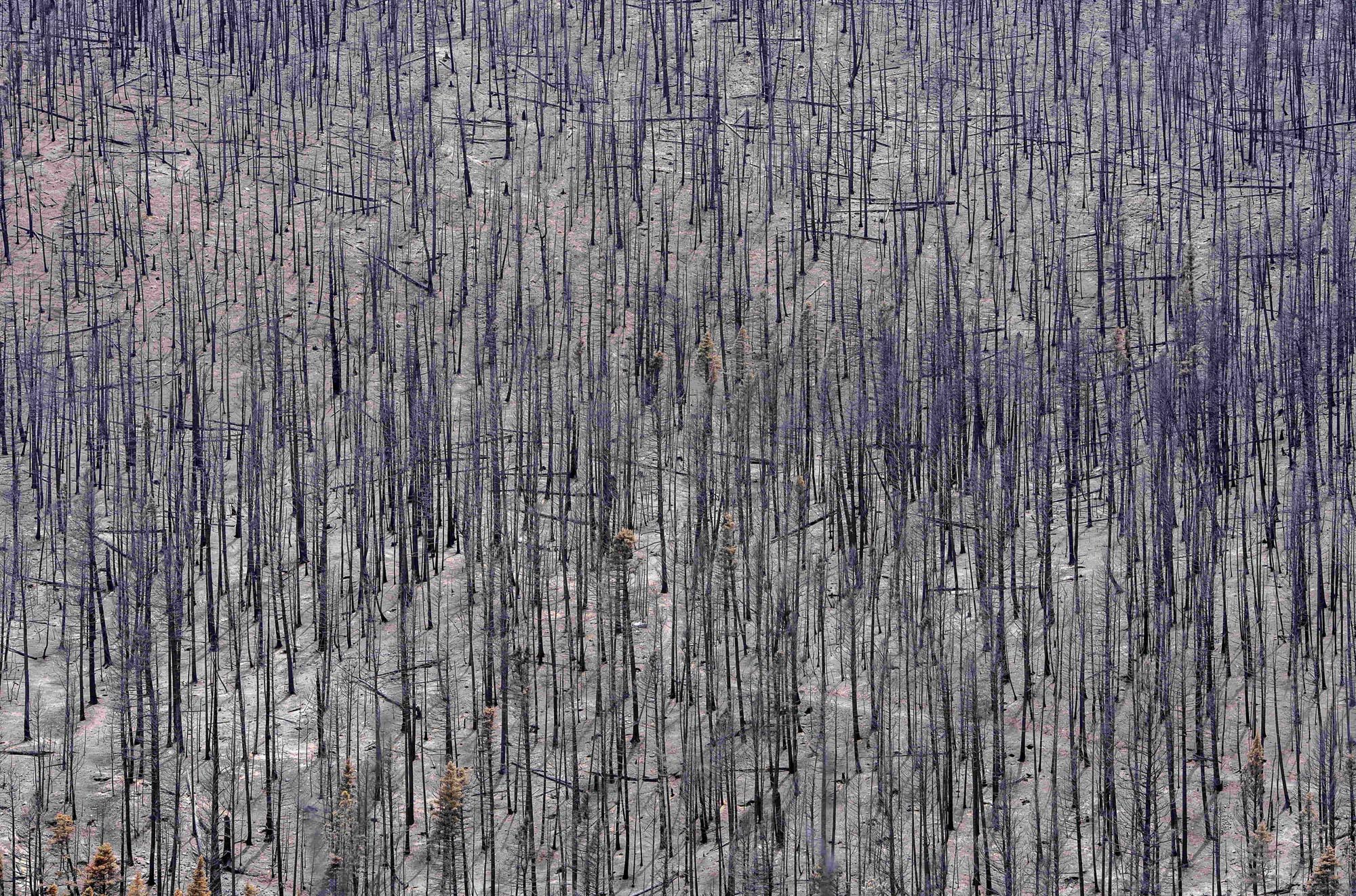
The forest in Mora County was scorched by the fire.
Eddie Moore/”Albuquerque Journal”/ZUMA PRESS
Joey Romero, the undersheriff of Mora County, helped evacuate residents. At first, it was chaos, he remembers — the mix of officials coming in from all across the state, with the Forest Service and National Guard and State Police all trying to pitch in. Soon, the area lost power, and a sort of surreal silence set in. He likened the experience to the 1980s dystopian war film Red Dawn, of being the only front left to face off against a fierce invader.
“Just seeing that crown, the fire coming over the mountain, it was one of those things you don’t ever think you’re going to experience,” he says.
The merged, massive wildfire ultimately took the Forest Service more than four months to contain.
THE FOREST SERVICE WEBSITE states that 99.84 percent of prescribed burns are carried out within their planned boundaries. That means there are less than two escapes, or fires that stray beyond those set perimeters, out of every 1,000 it lights. As the Calf Canyon/Hermit’s Peak wildfire burned, Forest Service chief Randy Moore announced the agency was instituting a 90-day pause in prescribed burning across the country in order to review prescribed-burn “protocols, decision support tools, and practices.”
Forest Service officials and outside experts pored over the April 6 plans, revisiting the conditions, communications, and minute-by-minute logs of the morning’s activities to put together their analysis. It identifies a number of mistakes. Officials failed to account for the impacts of climate change, the report claims, including just how dry conditions have become after years of historic drought in the region.
The issues went beyond that significant underestimation. There was a lack of adequate documentation at the start, communication breakdowns in the field, and insufficient contingency resources for suppression. The review notes that “district fire employees perceived pressure to ‘accomplish the mission,’ which may have led to taking greater risk.”
The authors use the term “error” to describe some of the issues, like the modeling mistakes. Stronger, often accusatory language is more popular among locals who will tell you they knew the conditions were wrong that windy morning. Michael Stuart Ani is one of them. A transplant to the area from Northern California, Ani and his wife, Heather Vuchinich, moved to San Miguel County in part to escape the fires that had forced them to evacuate multiple times. They now live at an address Google Maps gets wrong, down a series of dirt roads where the quirks of their neighbor’s homes — flags, signs, and paint colors — serve as landmarks in the directions Vuchinich sends me.
After I pass inspection from their two boisterous dogs, the couple welcome me into the adobe-style dwelling, their walls lined with photos from past travels. In his early seventies, dressed in a cowboy hat and buckled blue jeans, Ani cuts a classic Western figure, while Vuchinich, 54, is dressed casually, offering me tea and a few soft smiles, though concern lingers in her eyes. The fire spared their house, but a black line a few feet away from it in the backyard indicates just how lucky they were. The flames swallowed a historic bunkhouse on the wrong side of that divide.
There’s a pervasive anger about the situation throughout the burn scar, Ani explains, but the roots of the resentment begin in different soils for different residents. Ani speaks of the “computers” and “models” the Forest Service used to track fire behavior with air quotes; he believes the agency was too busy looking at screens to see what was happening in front of it, or to listen to what locals with deep knowledge of the region were saying.
“You came in and burned us out. You came with arrogance and destroyed our lives,” Ani says, hitting the table in front of him for emphasis. “That’s the crux of the whole problem here: You need to show us respect.”
Vuchinich is quieter and careful with her words, sending me articles and government reports to support her statements before and after we meet. Her distrust of the federal government stems from the fact that federal officials have made this sort of mistake in New Mexico before — not too long ago, really. In May 2000, National Park Service employees set a prescribed burn in a wooded area of Bandelier National Monument on the western side of the Santa Fe National Forest. It turned into a wildfire that destroyed 200 residential structures in the nearby city of Los Alamos. Much like the Calf Canyon/Hermit’s Peak aftermath, a rush of federal reports followed, identifying issues and outlining ways to prevent them next time.
Seeing similarities between the two responses has left Vuchinich skeptical that anything will change to prevent the next fire. Why should the federal government be trusted to do things differently after making the same mistake twice, she wants to ask, and why aren’t residents being given more of an opportunity to voice their concerns about their own land? She’s brought these questions with her to town halls and meetings hosted by federal agencies, by lawyers, and by local officials. There’s a cadence to these meetings though — the bulk of the time dedicated to presentations, with questions squeezed in at the end. Often, officials encourage those with concerns to connect with them after the meeting one-on-one, or promise they’ll get back to them at a later date.
“The message seems to be that the government really doesn’t care that much about what people think about how it should be restored,” Vuchinich says. “Whether or not that’s true, that’s what’s coming through.”
Distrust of the federal government and the Forest Service in particular stretches back more than a century here. In the 2015 book Enchantment and Exploitation, William deBuys offers a sweeping history of the region, including detailing the long-standing tensions between locals and Forest Service employees, who he described as having “two radically different perceptions of the land.” For locals, the land was their source of all sustenance, and tending to it was often a birthright. For the Forest Service, there were directives to follow to maintain federal property, even if they clashed with the locals’ understanding of the terrain.
DeBuys quotes one villager describing his interactions with the Forest Service in 1980: “Every time a new guy comes in, we have to fight his ideas. He may have a college degree, but we know the country. I’ve known it since I was a boy, and my boy, when he is my age, will know it as well as me.”
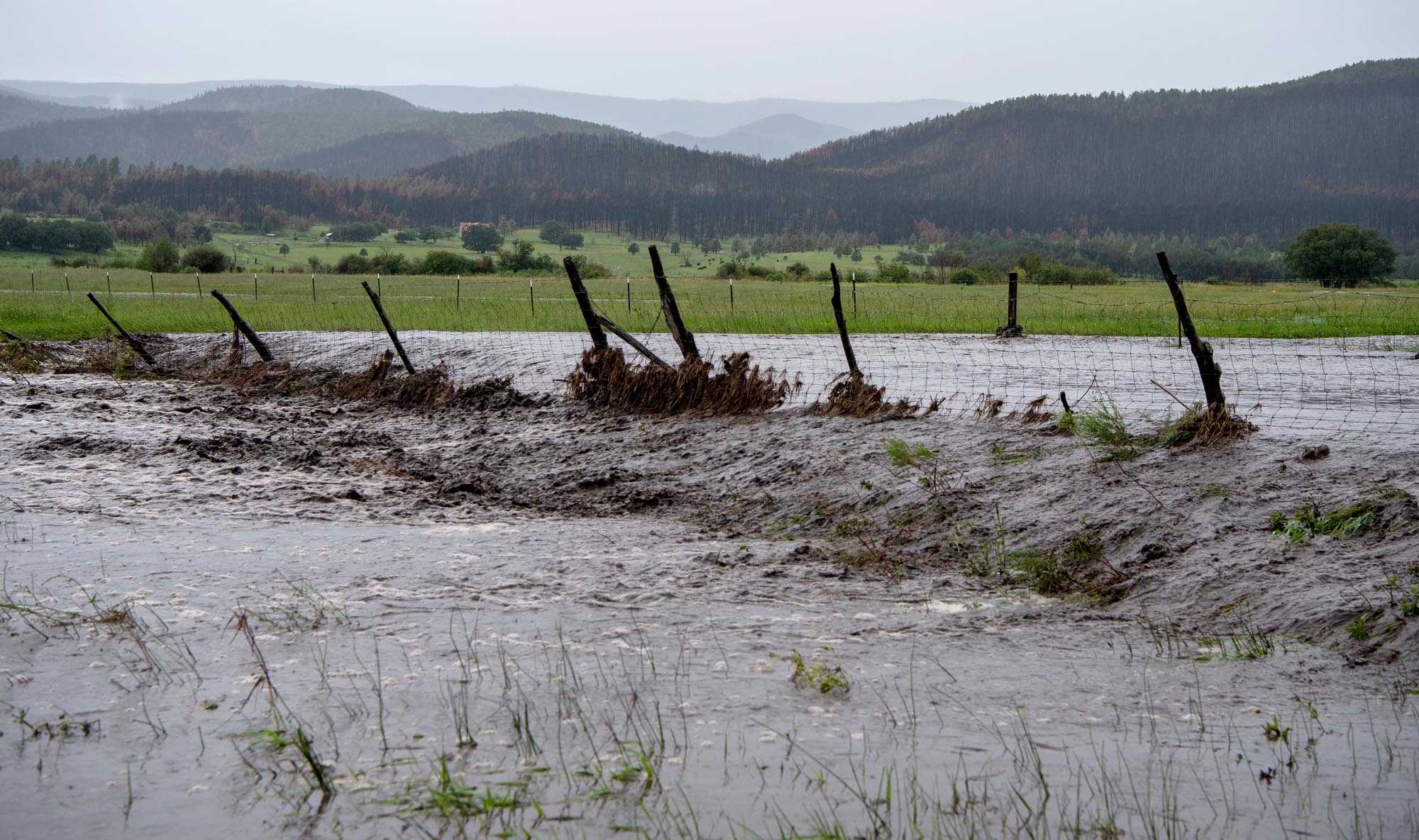
The burn led to flooding as the soil became “hydrophobic,” meaning it could not hold moisture. The subsequent floods lead to four deaths.
Eddie Moore/”Albuquerque Journal”/ZUMA Press
For many of the fire’s victims, their main interactions with the federal government have not been with the Forest Service directly, but rather through the Federal Emergency Management Agency, which is coordinating the distribution of the congressionally appropriated funds. FEMA set up two offices in the impacted counties to coordinate these applications, hiring local residents they trained to serve as “claims navigators” to walk neighbors through their options. One of the navigators, Yvette Arellanes, tells me she took the job to help others have a better experience with FEMA than she initially did.
As of this past February, FEMA reported doling out 1,586 payments to the sum of $405 million from the fund, which an agency spokesperson says covers more than half the claims with documentation it has received. Of those, 1,525 were to individuals, households, and family trusts. The following month, FEMA announced that the director of the Calf Canyon/Hermit’s Peak claims office, Angela Gladwell, was being reassigned within the agency as the office transitions into focusing “from development to effective delivery at the local level.”
Gladwell has a long résumé in the disaster-recovery space, but she found the Calf Canyon/Hermit’s Peak Fire process to be a “unique circumstance,” due to the federal government’s responsibility in causing the disaster.
Speaking to me in November, she acknowledged the slow pace of disbursement so far, and urged residents to continue registering with the agency and to be patient. But it’s not just the speed residents have taken issue with — FEMA is also being sued by some of the fire’s victims over its interpretation of the recovery legislation and what the agency is choosing to reimburse. Plaintiffs are fighting to receive “noneconomic damages,” which includes compensation for homeowners who cannot present proper paperwork, something fairly common in a place where ownership was often passed down rather than written down. A representative of FEMA tells me the agency is not commenting on any pending litigation.
Tucked away in the United Methodist Church in Las Vegas, the largest city impacted by the Calf Canyon/Hermit’s Peak Fire, a church- and small-donor-funded, resident-led group, Neighbors Helping Neighbors Fire Relief, has been coordinating aid for fire survivors. Founder Janna Lopez says it has assisted more than 400 clients, including acting as a liaison between government officials and residents. In her opinion, the government outreach to residents has equated to “a lot of lip service.” When I ask her why someone would go to Neighbors Helping Neighbors rather than working directly with FEMA, Lopez’s answer is quick and biting.
“We treat people like humans,” she says. “Like your grandmother or brother or sister, a neighbor, your child.”
“And they treat them like number 41-63572,” chimes in another volunteer, sitting at a desk across the room, who asks not to be named.
In a way, the federal government has set itself up to fail, Veronica Serna believes. The Mora County commissioner has become one of the most vocal advocates for those impacted by the fire, even testifying in front of Congress last year. She’s become known in the area for her post-fire tours, taking agency officials, politicians, and the occasional journalist on hourslong drives through the impacted region, visiting homeowners and recovery projects and a local diner, because she knows you’ll get hungry along the way. My tour takes place on an unseasonably cold fall day, a dusting of snow softening the blackened scenery around us.
Her issue is with the promise to “fully compensate” survivors — that’s just impossible, she says.
“You can’t ever make people whole, you can’t replace 100-year-old trees, at least not in our lifetime,” she tells me, her dark eyes set on the road ahead.
Today, Serna is just trying to find a way forward. A big part of that has been trying to help residents feel heard and act as a matchmaker of sorts between those in need and those with resources. On our first stop of the day, I meet Kathryn Uehlein, whose mountainside home burned down during the fire, along with the garden she used to grow vegetables. She now lives in an RV with a small wood-burning stove inside.
Serna convenes a small group to join me on our drive, a mix of state and federal officials working on the recovery efforts. She introduces us to locals, business owners, researchers, and the county deputy sheriff. I meet Army Corps officer Robert Zebrowski, one of the officials deployed to help lead flood mitigation efforts in areas washed out from the monsoon roads. He shows me a culvert the Corps had dug out to divert flood waters, which it had coupled with building man-made dirt berms, or walls, to help further channel the flow.
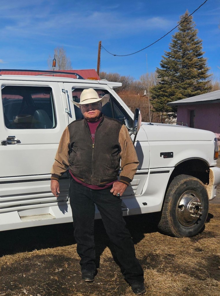
Roger Romero was unable to bury his son in the family plot because of the fire.
Courtesy of Roger Romero
He would have been the first of the ninth generation buried in our family cemetery. —Roger Romero
As we stand on the side, Roger Romero passes by in his car. He slows down after spotting a friendly face. He knows Zebrowski — in fact, the idea for the construction I’m being shown came from Romero, and some of the dirt dropped on the spot is actually from his land.
Romero has a background in working with heavy equipment, and he’d been giving his number out to officials from all sorts of agencies for months. Zebrowski was his most successful stop; as for the rest of them, “I don’t know if they’ve kept it,” Romero jokes.
Having his suggestion heard was a bright spot in a year that’s been otherwise difficult and demoralizing, he says. His home survived the fire, but his property did not make it out unscathed, and the damage to his fences and fields was compounded by the flooding. In November, not long after the fire and the floods finally subsided, Romero’s youngest son passed away. With the water-warped road to his family cemetery impassable, Romero was not able to bury him with his ancestors. He wondered how anything could be salvaged after this.
“He would have been the first of the ninth generation buried in our family cemetery,” Romero says. “So, it’s been devastating in a lot of ways.”
Romero is 71 years old. He knows he doesn’t have the decades left in his lifetime to see the land restored to what it was. But he hopes to be a part of the conversation about what happens next, and what the land will look like for the generations that follow him.
The thing about the fire is that recovering from it will never really be done, at least not if you do it right. Post-wildfire landscapes require ongoing maintenance to rebuild and reduce its risk to residents, and the Calf Canyon/Hermit’s Peak burn scar poses particularly salient threats due to the ongoing flood risks. Addressing that will continue to require interagency efforts, not to mention a continuing flow of funding.
Shaun Sanchez, the supervisor of the Santa Fe National Forest, said in an April 2023 public webinar that there are no plans in the “immediate foreseeable future” to put more fire on the ground in the burn-scar region. Roads need to be cleared, dead trees need to be removed, drains need to be emptied, homes need to be rebuilt. But there are burns already being conducted within the larger Santa Fe National Forest, which spans 1.6 million acres.
There’s a massive effort underway to revitalize the burned land, as well. As of early 2024, the New Mexico Natural Resources Conservation Service has mulched 30,000 acres and seeded 50,000 with a mix of annual and perennial native plants. This work is critical in stabilizing the soil and preventing more debris flows and erosion. The agency also has a long waiting list of areas to perform flood cleanup and mitigation.
Sanchez understands that building trust is another critical component to recovery. He occupies a unique space in the divide between federal officials and fire victims: a ninth-generation native of northern New Mexico, but one who has spent much of his career working for the federal government. When he introduces himself to me, he tells me his parents were among those evacuated during the Calf Canyon/Hermit’s Peak Fire.
When I ask Sanchez what his advice is for residents like Ani or Vuchinich or Romero, who are eager to have their concerns heard, he suggests they call him directly. One-on-one conversations between federal officials and the thousands impacted by the burns is a daunting and admittedly unlikely task. But community-centered approaches to forest management have proven successful in giving people a forum to really be heard and have their questions addressed. The Forest Stewards Guild, a nonprofit based in Santa Fe, has been hosting prescribed burns for the past decade in partnership with a mix of tribal, local, state, federal, nonprofit, and private partners. Part of its preburn communication plan involves community meetings, explains Eytan Krasilovsky, the Stewards Guild’s deputy director.
In Las Vegas, Luna Community College hosted workshops to help residents address common land-management issues on their properties, like reseeding their yards or filling in bulldozer tracks. The courses were popular enough that they applied for a grant from the U.S. Department of Agriculture to develop certification programs that will teach some of the skills required in recovery and ongoing landscape management. This past summer, the USDA awarded the school $3 million to start a Wildfire Resiliency Training Center. Rafael D’Amato, the director, is a former fire chief, and he hopes the program can create opportunities for residents to have more of a say and hand in shaping the on-the-ground recovery.
“It’s where they live, and they want to be involved,” D’Amato says. “The forest is theirs, as well as everybody else’s.”